
If you’re looking for what to see and do in La Palma, the most useful thing is to organize it by areas and by type of plan. It’s not the easiest island for improvising ten stops in one day, but it is one of the best for mixing volcanoes, viewpoints, rainforests, natural pools, clear skies, and quiet villages with plenty of scenery in between.
Here, it usually works better to choose a few good visits and combine them well rather than trying to do too much. La Palma is especially great for a couple’s trip, a relaxing car getaway, gentle hiking, or a week in nature, and depending on your days, it’s worth prioritizing the summit, the volcanic south, or the green northeast. If you prefer to start with a shorter, more organized version before diving into the details, in La Palma guide you’ll find a summary by area and travel pace, and in Turismo Canarias homepage you can compare the rest of the islands already covered.
- Very solid must-sees: Caldera de Taburiente, Roque de los Muchachos, San Antonio volcano, the Fuencaliente salt pans and Santa Cruz de La Palma.
- If you’re looking for relaxing activities: viewpoints, leisurely walks through villages and time to enjoy the night sky rather than a rushed tour.
- If you like swimming: Charco Azul and the coast of Puerto Naos or Tazacorte usually fit better than trying to find a beach anywhere on the island.
- If hiking is your thing: Los Tilos, Cubo de la Galga, and the Route of the Volcanoes are the three names worth planning from the start.
- If you’re only going for 2 or 3 days: focus on 4 or 5 good stops and avoid crossing the island multiple times unnecessarily.
Quick tips for planning the route
- 2 or 3 days: summit and interior one day, volcanic south another, and leave the northeast only if you still have time.
- 4 or 5 days: You can now divide the island into zones and combine Santa Cruz with the green north without rushing.
- 6 or 7 days: This is when La Palma is most enjoyable because you can leave room for viewpoints, swimming, trails, and a stargazing night.
- Getting around: It’s the most practical way to get around. There are curves, elevation changes, and quick weather shifts between the coast and the summit.
- Best approach: decide each day by area, not by a list of names.
Interior and summit of the island
This part has some of La Palma’s most memorable landscapes. If it’s your first trip, it’s usually the best starting point to understand the island and later decide if you want more coast, volcano, or hiking.
Caldera de Taburiente and its trails


La Caldera de Taburiente is a spectacular National Park located in the heart of La Palma. This protected natural area, whose name comes from the indigenous word ‘taburiente,’ used to refer to vast plains, is actually a huge depression surrounded by peaks. In this national park, we also find the Roque de los Muchachos astronomical observatory, one of the most powerful telescope arrays in the world, placed in La Palma because of the clarity of its skies and the sharpness for observing space.
La Caldera is one of the largest eroded craters in the world, and its current appearance is the result of millions of years of geological activity. Walking along its trails is like traveling through time, immersing yourself in the island’s history and discovering endemic fauna and flora that you can only see here. Whether strolling through the Canary pine forests, swimming in the crystal-clear waters of its streams, or simply enjoying the spectacular views, your visit to the Caldera de Taburiente will be unforgettable.
Roque de los Muchachos and the great panoramic view of the island
At 2,428 metres above sea level, Roque de los Muchachos is La Palma’s highest point and one of its most impressive viewpoints. Look across Caldera de Taburiente, the island’s ridges and the Atlantic coast. In clear conditions, you may also see Tenerife, La Gomera and El Hierro.


Access to the summit of Roque de los Muchachos is very easy since you can reach it by road without any problem. Along the way, we can enjoy the island’s flora, especially colorful between spring and summer, thanks to the blooming of the Tajinastes.
Volcanic south and west coast
If you feel like exploring the more volcanic side of La Palma, this is the area that works best. You can easily spend a full day in Fuencaliente and another in the Aridane valley, especially if you want to mix landscapes, viewpoints, a bit of beach, and some sea activities.
San Antonio Volcano and southern viewpoints
San Antonio Volcano, located in Fuencaliente, is another of the island’s main geological attractions. In the Cumbre Vieja Natural Park, visitors can enjoy an impressive landscape characterized by lava flows, volcanic cones, and unique flora and fauna. The short hiking trail that goes around the crater’s rim, lasting about 30 minutes, offers spectacular panoramic views of the crater, the southern coast, and Teneguía Volcano, whose last eruption occurred in 1971. On clear days, we can see the neighboring islands of Tenerife, La Gomera, and El Hierro.
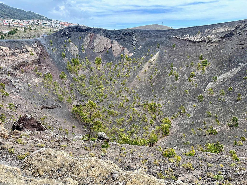

At the entrance of the volcano, you’ll find the San Antonio Volcano Visitor Center, which allows visitors to learn about the geological processes that have shaped La Palma over millions of years and the history of volcanic eruptions in the area. This visitor center requires an entrance fee, but it’s cheap and we found it quite interesting for learning about La Palma’s history, including the recent Tajogaite eruption in 2021. There are also free and very interesting routes in the area, like the descent from the volcano to the Fuencaliente lighthouse.
Fuencaliente Salt Pans and Lighthouse
At the southern tip of the island, you’ll find the Fuencaliente Salt Pans, where seawater is evaporated to produce salt. The contrast between the white salt piles, the blue sea, and the black volcanic ground creates a unique landscape.
Located in the municipality of Fuencaliente, in the south of the island, the Salt Flats and the Lighthouse are a must-visit. These salt flats, which are still in operation, are one of the few left in the Canary Islands and entrance is free, making them a must-see for travelers in La Palma.
The contrast of the piles of white salt, the changing colored ponds, the volcanic black earth, and the deep blue sea, along with the wildlife that inhabits the waters, like migratory birds and crabs, makes this place a unique setting.
This area, declared of scientific interest in the 1990s, actually consists of two lighthouses. The old one is over 100 years old and houses the interpretation center for the La Palma marine reserve. The new one is 24 meters tall and is the one currently in operation.

El Time viewpoint and views of the Aridane Valley
Mirador de El Time overlooks the Aridane Valley and Los Llanos de Aridane. It is also a place to appreciate the scale of the landscape changed by the 2021 Tajogaite eruption, whose lava flows reached the sea.
The views are stunning and really make us understand the force of nature and how this 2021 eruption took everything in its path. Since then, work has been done to try to recover the area, like roads, but hundreds of houses and banana plantations were buried under lava. We can also get closer views of the volcano and its lava flows from a small viewpoint at the Tajuya church, right next to the road.


Puerto Naos and Tazacorte for beach and strolling
The black sand beaches of Puerto Naos are perfect for sunbathing and relaxing. Here we can find the largest beach on La Isla Bonita, surrounded by amenities like bars and restaurants, and flying the blue flag since 2007. This area is also a meeting point for paragliding enthusiasts, where we can watch aerial shows or try this high-altitude sport with stunning views.


In Tazacorte, we can also find spectacular black sand beaches, but this time less accessible and with fewer amenities, ideal for lovers of untouched nature. Beyond Tazacorte’s port, this town surrounded by banana plantations boasts a heritage site of great historical and artistic value. It’s a stop that works well if you feel like combining a swim, a seaside stroll, and a peaceful walk among banana plantations and the town center.
Cueva Bonita by kayak or boat
Cueva Bonita, on the coast of Tijarafe, is a volcanic sea cave reached only from the water. Boat and kayak excursions explore this stretch of coast near Porís de Candelaria when conditions allow. The cave has two entrances, one to the north and one to the south.

With a favorable tide, you can also get close to a small pebble beach. In July, the evening sun rays enter from the north side of the cave, creating a natural spectacle since the colors change almost by the minute. It is said that during the era of pirate attacks, many fishermen saved their lives thanks to this cave, as they would enter from one side and exit from the other. Meanwhile, the pirates would wait for them to come out where they had entered, unaware of the cave’s existence.
The green north and northeast
For lush forest and greener scenery, explore San Andrés y Sauces, Puntallana and Garafía. Group forest walks, coastal stops and scenic drives into manageable half-day outings.
Charco Azul, the most comfortable natural pool

Charco Azul is one of the most impressive natural pools on La Palma. Located in the municipality of San Andrés y Sauces, on the northeast coast of the island, this pool is the result of volcanic erosion, where the sea and volcanic rocks have created a unique space for swimming.
With its crystal-clear water and rock formations, Charco Azul is the perfect spot for a relaxing day. Plus, the area has facilities like changing rooms, restrooms, a solarium, and a bar, making it ideal for a family day out. Don’t forget your snorkeling gear to explore the rich marine life in its waters.
There is no admission charge, and an artificial pool sits alongside it. Check local notices and sea conditions before swimming, and do not enter when the site is closed or waves make it unsafe.
Los Tilos Forest and waterfall
Los Tilos is one of La Palma’s best-known laurel forests, in the Parque Natural de Las Nieves in the northeast. Dense vegetation, ferns and forest trails make it a rewarding area to explore on foot. Choose a route suited to your time and check access before setting off.
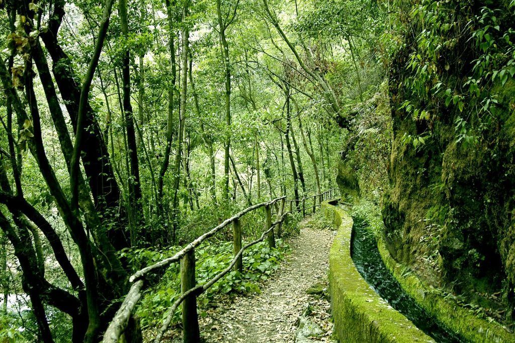
A short walk from the visitor centre leads towards the well-known Los Tilos waterfall. The damp, green surroundings make this a striking stop in the northeast. Check current access conditions before planning your visit.
Cubo de la Galga, an easy trail through laurel forest
Another one of La Palma’s interesting routes to explore the island’s mountains on foot is called El Cubo de la Galga. In the municipality of Puntallana, within the Parque Natural de Las Nieves, this area has walking routes through fern-filled laurel forest.
There are different routes in the area that we can choose from depending on our preferences. In our case, we did a route of about 5 km, taking roughly 2 hours. We made plenty of stops to enjoy the forest and the views it offers. Most routes are circular, with the longest being 12 kilometers, but they are of low difficulty, making them suitable to enjoy with children.
The Cubo de la Galga route links with Mirador de San Bartolomé, taking you through the island’s green mountain scenery. Nearby picnic areas provide places to stop and rest.

The dragon trees of Buracas
The Dragon Tree is an endemic tree of the Atlantic archipelagos known as Macaronesia, among which we find the Canary Islands. Although the most famous Dragon Tree can be found in Tenerife (The Thousand-Year-Old Dragon Tree of Icod de los Vinos), these types of trees are abundant in La Palma. One of the most spectacular areas where we can see a large number of them is in the municipality of Garafía, where we find the famous Dragos de Buracas.

These dragon trees, with their twisted shapes and dark green color, are one of those stops that work best if you’re in the mood for rural landscapes and an easy, short walk. Canary Island dragon trees are known for their slow growth and have a wide ornamental use, making this area a picturesque landscape.
Getting to the Buracas dragon trees area can be a bit tricky if you’re not familiar with the area, since Google was directing us through impassable roads. To access this simple hiking spot, you can drive along the road by the bus stop “Entrada Buracas.” On the way, you’ll also find the Gofio museum or the Buracas Caves, recommended stops if you have enough time.
Roques de Garafía and the northwest coast
In the northwest area of La Palma, we find the Roques de Garafía, a group of volcanic rocks off the coast of the island’s cliffs. This area is a refuge for various seabirds and is of great wildlife interest because it is a breeding and nesting area for different protected species.

It’s a somewhat remote stop, but the road access to the Santo Domingo de Garafía viewpoint is easy. Once there, we can go down a stone path where we can even take a dip in a natural pool that we find by the sea. We found it interesting to discover that in different areas of the mountain there were fishermen’s settlements that had turned caves into homes.
Santa Cruz and calm plans
The capital often gets left off many quick lists, but for a real trip, it’s very useful. It serves as a comfortable base, has a relaxed vibe, and helps balance several days on the road and in the mountains.
Santa Cruz de La Palma: a convenient base
The island’s capital, Santa Cruz de La Palma, is charming. Its cobblestone streets and colorful houses transport you to another era, while its lively atmosphere and rich history make it a must-stop on your trip.
It’s an ideal place to set up our base and explore the island, since besides a lot of hotels, Airbnbs, and restaurants, we can find various bars to grab a drink. After a day of driving and viewpoint-hopping, it’s easy to have a good dinner and rest here without having to move the car again.
In the old town of the city, every corner is full of history. From the Church of El Salvador, with its impressive façade and beautiful altarpieces, to the Insular Museum, where you can learn more about the island’s culture and traditions. And if you feel like taking a break, you can sit in one of the many cafés and restaurants with sea views, and enjoy the exquisite local cuisine.
If you want to better understand the historical background of the archipelago before exploring old towns and buildings, here is a clear summary of the History of the Conquest of the Canary Islands.

Night sky and hiking
La Palma is especially enjoyable when you leave room for a night of stargazing or a long walking route. You don’t need to do both plans on the same trip, but it’s good to decide beforehand because both depend a lot on the weather and the fatigue you might have from driving.
Where to see stars in La Palma
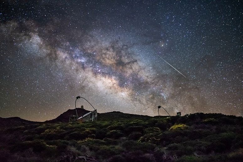
The Canary Islands are an exceptional place for stargazing, due to their location and the lack of major light pollution. In particular, the IAC group of observatories, with one on Roque de los Muchachos in La Palma and another in Las Cañadas del Teide in Tenerife, are among the most important in the world.
In 2012, La Palma was recognized as a Starlight tourist destination, becoming the first certified world reserve thanks to the quality of its sky. At night, almost the entire island offers excellent spots to observe the millions of stars that surround us.
Visiting the island, we will see plenty of star-gazing spots along the road, which are perfect for enjoying a starry night with the naked eye or with a telescope. The Taburiente Caldera or the Fuencaliente Salt Flats are especially magical places at night. We can also hire a tour with explanations and provided equipment. Some tours also include visits to the IAC observatory, lasting about 90 minutes.
Ruta de los Volcanes: a long-distance walk through the south
The Route of the Volcanoes on the island of La Palma is one of the most iconic in the Canary Islands, offering a unique volcanic landscape along its nearly 18 km. Starting at the El Pilar Refuge at 1450 meters above sea level, the trail passes through old and recent craters, climbing up to almost 2000 meters in Las Deseadas and then descending south towards FuencalienteThe route, which can be challenging in some sections, offers spectacular and panoramic views on both sides of the island.

The diversity of landscapes and natural points of interest are an integral part of the hiking experience on this trail. There are countless stops of interest such as Pico Birigoyo, the Hoyo Negro crater, and Martín Volcano, among others. In addition to the volcanoes, the Canary pine forests, a dominant plant species on the island, play an important role in the local ecosystem, even providing fertile soil after fires. The route ends in the village of Los Canarios, where you’ll find plenty of bars and restaurants to recharge. The more adventurous can extend the path by visiting San Antonio Volcano or even reaching the Fuencaliente Lighthouse, passing by Teneguía Volcano.
It is essential for hikers to carry proper gear, including suitable clothing and footwear for hiking, as well as food, water, and sun protection. Before setting out on the hike, it’s recommended to check the trail conditions and the weather. The Route of the Volcanoes is not only a physical challenge but also a window into the geological and social history of La Palma. The trail was used in the past by merchants and farmers to cross the island.
How to divide your visit according to your days
- Short getaway: Caldera de Taburiente or Roque de los Muchachos, Santa Cruz, and a day in Fuencaliente.
- 4 or 5-day trip: add Charco Azul, Los Tilos, El Time, and an afternoon on the coast at Tazacorte or Puerto Naos.
- Full week: now you can take a long trail like the Route of the Volcanoes or a more unique plan like Cueva Bonita without feeling like you’re rushing.
For another island with a relaxed pace, striking scenery and rewarding road trips, take a look at our guide to what to see in El Hierro. To compare more destinations, return to Turismo Canarias homepage you have the rest of the guides already published.